|
FOTOGRAMMETRIA - CARTOGRAFIA - TOPOGRAFIA SISTEMI
INFORMATIVI TERRITORIALI |
||
|
|
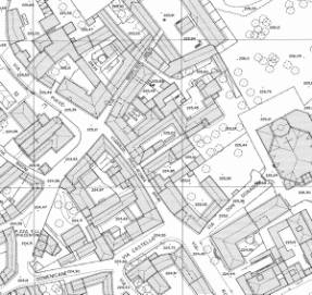
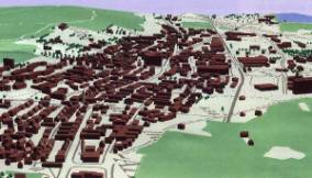
Cartography Our company produces cartography
for technical and land office uses. The majority of digital data
currently comes from photo interpretation of aerial photographs. Soft copy
workstations are used to digitalize features directly from stereo pairs of
digital photographs. These systems allow data to be captured in two and three
dimensions, with elevations measured directly from a stereo pair using
principles of photogrammetric. We can also
create data systems for Geographic Information Systems, merging cartography
and database technology. These are used by our major client, the Public
sector. They can use these data for a series of practical things, such as the
support their IT facilities/ systems, resource management, environmental
impact assessment, urban planning, cartography, prospective mapping, and
other purposes. For example, the data collected might allow emergency
planners to easily calculate emergency response times (i.e. logistics) in the
event of a natural disaster, or it might be used to find wetlands that need
protection from pollution. Our major client is the Public sector and we are
able to supply graphic data that feed the territorial information system. The final
product that we are able to provide can be created ex novo. On the other hand
we can also update existing material. We use the
latest digital tools for the following items: -
Aerophotogrammetry on different scales -
Topographic database -
Digital orthophoto -
Update of pre exhisitng carthography -
Land
register maps |
|
CANAVESI S.R.L. Viale
Vittorio Emanuele, 23 – 24121 BERGAMO (Italy)
Tel. +39 035 237680 - email : info@canavesi.it